
Our Flooding Futures: Risk and Adaptation to Flooding in New Zealand
Environmental Science and Natural Hazards| Rhiannon Thomas
Glossary
Groundwater: water stored underground in the fractures and pore spaces between rocks, soil, and sand.
Riparian planting: the process of planting trees, shrubs, and grasses along the edges of water bodies (such as streams, rivers, lakes, and wetlands) to create a natural buffer zone.
Flooding is the most frequent natural hazard in New Zealand [1], and the second-most costly [2]. From 2020–2025, there were 11 flooding events of note, including the Auckland Anniversary floods, 2024 Otago floods, and the winter 2025 Nelson/Tasman floods.
Floods and risk factors
There are three main types of floods: riverine, coastal, and flash. Riverine floods occur when a river breaches its banks and overflows onto the surrounding land. These typically occur when rainfall levels exceed the drainage capacity of the catchment. Coastal floods occur in low-lying coastal areas, where sea level rise is a contributing factor [3]. Phenomena such as storm surge also contribute. Flash floods occur when a high intensity and volume of water cause flooding in a brief period [4]. These floods may be triggered by high intensity rainfall (such as that seen during cyclones), rapid snow or ice melt, or dam failure [1]. These often allow little time for warning and response.
Across all flood types, drainage capacity plays a critical role in determining flood severity. Effective drainage reduces the depth and duration of inundation, while poor drainage intensifies the impacts. Key factors influencing drainage include geology (soil and rock type), soil saturation, and the extent of impervious surfaces such as concrete and asphalt, which limit infiltration [4], [5].
In coastal areas, there are additional factors that increase the risk of flooding. The first is tides and waves [3], as higher tides and larger waves can bring more water inland. Another factor is storm surge [3], a major contributor and commonly associated with low-pressure weather systems such as cyclones and severe storms. Reduced atmospheric pressure allows sea levels to rise, producing storm surge increases of 30–50 cm around New Zealand, with a 1 in 100 year event reaching around 90 cm [6].
Tectonics can also affect the exposure of a location to coastal flooding. Land that is subsiding due to tectonics is more vulnerable to coastal flooding [3], [5]. This can be seen in New Zealand, with subsiding areas like Thames being prone to frequent flooding. Finally, long-term sea level rise amplifies the impacts of all other drivers of coastal flooding. With 67% of New Zealand’s population living in coastal areas, and 94% of that coastal population residing in urban environments [7], the nation is especially vulnerable to coastal flood risk.
Case study: Auckland
On January 27th, 2023, Auckland received 160 mm of rainfall in the Auckland Anniversary floods. These were the worst floods in Auckland’s modern history and, at the time, the costliest non-earthquake event in New Zealand’s history.
A major factor contributing to the volume of rainfall experienced was the La Niña conditions at the time. La Niña is part of the El Niño–Southern Oscillation, a cycle of interactions between the surface of the Pacific Ocean and the atmosphere [8]. During La Niña, strengthened trade winds transport warm, moisture rich air towards New Zealand, increasing the likelihood of extreme rainfall. In contrast, El Niño conditions are typically associated with weaker trade winds and drier conditions across much of the country.
Auckland is particularly prone to flash flooding. Extensive impervious surfaces such as concrete and asphalt, combined with poorly draining clay soils in parts of the south and west, significantly limit infiltration and exacerbate surface water pooling.
Furthermore, Auckland’s volcanic landscape makes it more vulnerable to flooding, increasing flood risk by concentrating runoff into low lying and downslope areas, where water can accumulate rapidly during intense rainfall. Flooding occurs most frequently in suburbs with streams and waterways, including Mount Roskill, New Lynn, and Manurewa, where overland flow and channel overflow are common during extreme rainfall events.
Together, these climatic and physical factors make Auckland an example of urban flash flood risk.
Case Study: South Dunedin
South Dunedin is particularly vulnerable to future flooding due to a combination of low elevation, coastal exposure, and drainage issues. It is a low lying coastal area built partly on reclaimed land, with much of the surface lying less than 50 cm below the high tide line in suburbs such as St Kilda, Forbury, and Tainui [22]. This vulnerability is heightened by the lack of natural or engineered protection from waves and storm surge. The only barrier between the ocean and the suburbs of St Kilda and St Clair is a large sand dune, which is prone to erosion and therefore provides limited long term protection against coastal flooding.
A key factor distinguishing South Dunedin from other flood prone areas is its severe drainage problems. In some places, Dunedin’s water table lies just 20–30 cm below the surface, leaving little capacity for infiltration during both high rainfall and coastal inundation events [22]. This results in widespread surface runoff, as excess water cannot drain into the subsurface. Under sea level rise scenarios, the groundwater table is expected to rise linearly [23]. As no rivers flow through South Dunedin, the area is entirely reliant on underground drainage pipes for water removal [24], increasing vulnerability if the system is overwhelmed or fails. Collectively, these factors substantially increase South Dunedin’s susceptibility to groundwater inundation and coastal flooding under future sea level rise. \
When Dunedin was settled, the swampy area in the harbour was filled in using sand, forming the area now known as South Dunedin [23]. This has resulted in low lying, poorly draining ground that remains highly susceptible to flooding. Since then, the area has been heavily urbanised, with extensive asphalt coverage further reducing natural drainage capacity.
In 2015, major flooding in South Dunedin following 175 mm of rain in 24 hours damaged 1,200 buildings and caused $138 million in damage [26], [27]. The Portobello water pumping station failed [24], causing the flood to be 20 cm higher than it otherwise would have been [28]. This event demonstrated that South Dunedin’s drainage and pumping infrastructure was insufficient to cope with future extreme rainfall events.
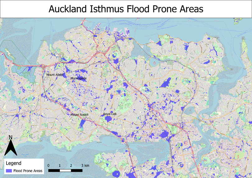
Figure 1. Flood prone areas in the Auckland isthmus. Souce: Auckland Council [9].
In many parts of Auckland, adaptive measures are being implemented to reduce the impacts of flooding. The Making Space for Water project, run by Auckland Council, was launched in 2024 in response to the Auckland Anniversary flooding [10]. The Community Flood Resilience programme complements this work by engaging with community organisations to strengthen flood resilience in affected suburbs and increase local awareness of flood risk [11].
As part of these initiatives, work is being done to restore Oakley Creek in Mount Roskill, an area particularly affected by flooding [11]. This involved removing legacy concrete piping, restoring the creek and its tributaries to a more natural form, increasing channel capacity, and improving the drainage of overland flow during flooding events [12]. Riparian planting around the creek increases catchment water retention, further reducing flood risk [13].
In addition to river restoration, Auckland has adopted multi-functional infrastructure like floodable parks to manage excess stormwater, such as Greenslade Reserve in Northcote [14]. These parks function as recreational spaces under normal conditions but are designed to temporarily store floodwater during high rainfall events. During the Auckland Anniversary flooding, Greenslade Reserve effectively reduced flood impacts, preventing much of the damage observed during earlier events.
Case study: Nelson/Tasman
Nelson is a city in New Zealand that is highly vulnerable to riverine flooding. The Maitai River runs through the centre of the city and can overtop its banks during high rainfall events. In addition, the Nelson region is characterised by silt and clay soils, which drain poorly and become easily waterlogged, increasing surface runoff [15]. As a coastal city, Nelson is also vulnerable to coastal inundation and sea level rise. Around 5,000 properties in Nelson are vulnerable to flooding [16].
In February 2018, Nelson and Tasman were hit by two ex-tropical cyclones in succession: Cyclone Fehi on February 1st and Cyclone Gita on February 20th and 21st [17]. Cyclone Fehi also coincided with a king tide, during which high tides are higher than usual [18], leading to increased coastal inundation. A storm surge of 35 cm, combined with winds pushing towards the shore caused devastation along the coastline [19].
More recently, Nelson, Tasman, and Marlborough experienced another sequence of severe flooding events in June and July of 2025. During the final week of June, the region was impacted by a 1 in 100 year rainfall event, resulting in the declaration of a state of emergency on June 27th. Rising water levels in the Wairau River prompted the preemptive evacuation of Spring Creek, while flooding led to the closure of State Highway 60 and damage to telecommunications infrastructure [17].
A subsequent weather system began on July 3rd, allowing little time for recovery between events. Elevated groundwater tables and river levels following the earlier flooding meant that additional rainfall was expected to cause significant impacts. This was followed by another 1 in 100 year rainfall event on July 11th, accompanied by high winds that brought down trees. As a result, State Highways 60 and 6, along with numerous local roads, were closed due to flooding, slips, and fallen trees. During this period, much of the region’s critical infrastructure was disrupted, leading to the loss of telecommunications, sewerage systems, electricity, and drinking water supplies. In this event, the Wai-iti River changed its course, also altering the alignment of associated streams and culverts [17].
Sediment transport further amplified the impacts of flooding in the region. Due to the silty nature of local soils, large volumes of sediment were suspended in floodwaters and deposited across flat land and paddocks as waters receded. Nelson has moderate to high soil erodibility [20], increasing its susceptibility to erosion and sedimentation during flood events.
In response to ongoing flood risk, Nelson City Council is developing long-term adaptation options for future natural hazards, including flooding. Adaptation planning is currently focused on the suburb of The Wood, due to its high exposure to flood hazards and cultural significance [21]. The Wood is located on the eastern bank of the Maitai River and along the coastline, making it vulnerable to riverine flooding, coastal inundation, coastal erosion, and sea level rise [16]. The council is using the PARA framework (Protect, Avoid, Relocate, Accommodate) to develop solutions and is collaborating with the community and iwi to find the most appropriate adaptation pathway [21].
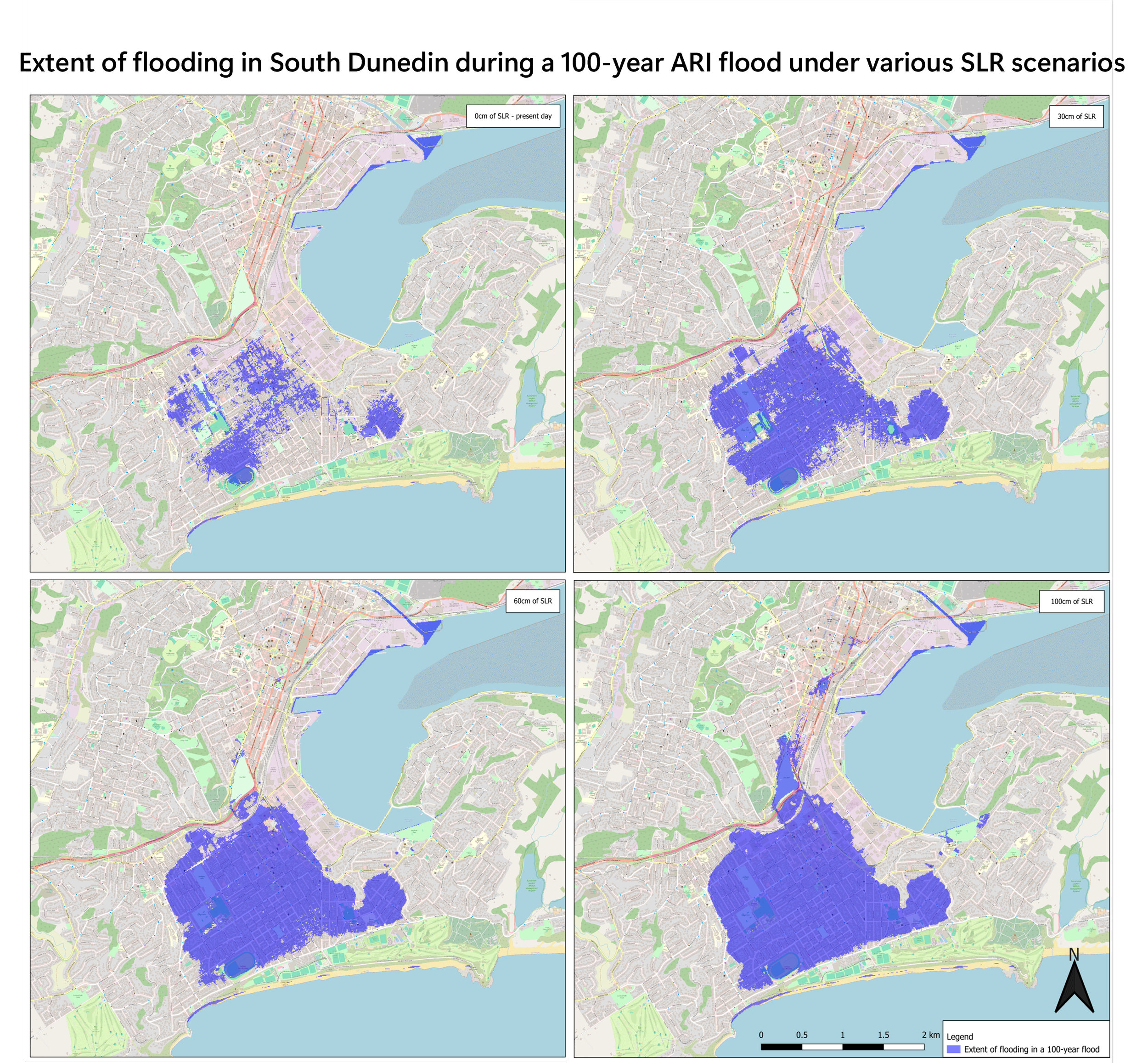
Figure 2: Map showing extent of flooding due to zero groundwater storage during a 100-year flood in South Dunedin under 0 cm, 30 cm, 60 cm, and 100 cm of sea level rise. Source: Otago Regional Council [25].
In October 2024, another significant flooding event affected the Otago region, with Dunedin receiving 160 mm of rain over 48 hours and the hill suburbs recording up to 180 mm across October 3rd and 4th [29]. As a result, 60 homes in the South Dunedin suburbs of Caversham and Forbury were evacuated, while widespread surface flooding was reported across the wider area. Although rainfall during this event exceeded that of the 2015 flood, improved pumping infrastructure meant that property damage was significantly reduced.
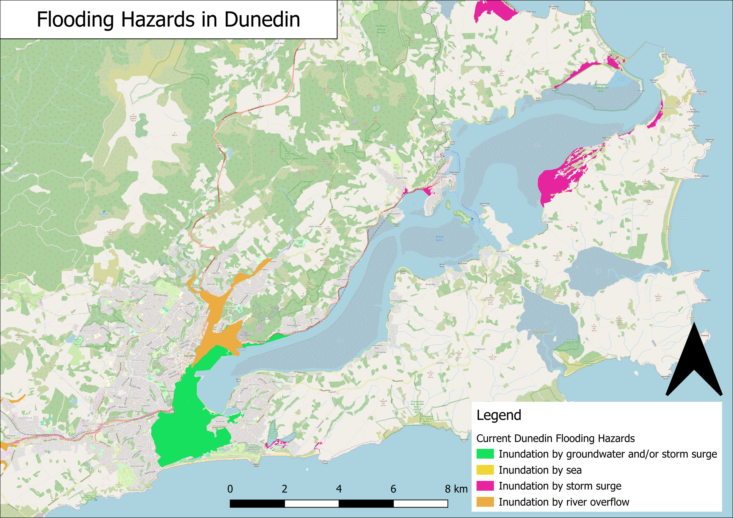
Figure 3.Map showing the types of flooding hazard across Dunedin. Source: Otago Regional Council [25].
Following the repeated flooding events in South Dunedin, the Otago Regional Council initiated a long-term project aimed at improving flood resilience over the next 75 years [30] The process began with a comprehensive risk assessment, followed by the development of six adaptation options with estimated costs ranging from $2.8 billion to $7.1 billion. These options were estimated to deliver benefits of up to $4.5 billion through reduced flood damage, showing the potential economic value of proactive adaptation.
The options include a range of structural and nature-based strategies, such as enhanced pumping, land elevation, restoration of wetlands and waterways to store excess water, and the managed retreat of South Dunedin. A ‘status quo’ option was also assessed, in which no action would be taken to address future flood risk; this option was estimated to result in approximately $2 billion in flood related damage.
Each of the seven options would result in different social, economic, and environmental outcomes and was evaluated against these criteria following community consultation. Three options have been shortlisted as offering the most effective long-term outcomes while being relatively quicker to implement [31]. These options are Future 3 (elevating land and pumping water), Future 4 (waterways and wetlands), and Future 5 (waterways and raised land). Community consultation is set to continue, and a final option will be chosen by the end of 2026.
While long term planning continues, the Dunedin City Council is implementing three interim pipe and pumping projects, set to cost $29 million and reduce flood risk by 10–20%. South Dunedin is an example of a work in progress to improve urban resilience to flooding under increased climate risk.
National response
Although regional and city councils are taking action to adapt to increasing flood risk across New Zealand, the central government has recognised the need for a coordinated national framework. The National Adaptation Framework, published in October 2025 [32], sets out a national approach to climate change adaptation, with a focus on floods and storms.
The Framework is structured around four key pillars:
Risk and response information sharing,
Roles and responsibilities,
Investment in risk reduction, and
Cost-sharing pre- and post-event.
Together, these pillars contain 16 actions that collectively aim to improve New Zealand’s resilience to flooding and other climate hazards.
The very first action in the Framework is to develop a National Flood Map, which will standardise flood hazard data nationwide and enable consistent flood risk assessment at all scales. This map is set to be published in 2027 and will be readily available for anyone to view and use. Other key actions include developing new hazard datasets and improving the information used in resource consenting so that new properties and infrastructure are designed with future climate risks in mind.
Under roles and responsibilities, actions are aimed at clarifying where responsibility for managing risk lies. Under this pillar, guidance is provided for individuals and insurers to manage risk at a household or organisational level, for councils to oversee preparedness and response to adverse events, and for central government to establish regulations and national standards.
Investment in risk reduction is intended to address flood risks proactively, minimising the economic and social impacts of adverse events. Cost sharing before and after flood events is designed to incentivise proactive risk reduction and support the long-term management of climate related hazards.
Together, these actions provide a national framework to support local flood adaptation efforts and improve New Zealand’s overall resilience to increasing flood risk.
[1] Natural Hazards Portal. “Storms and Floods.” Accessed: Mar. 19, 2026. [Online]. Available: https://www.naturalhazardsportal.govt.nz/s/natural-hazard-risk/about-natural-hazard-risk/storms-and-floods.
[2] Insurance Council of New Zealand. “Cost of natural disasters.” Accessed: Mar. 19, 2026. [Online]. Available: https://www.icnz.org.nz/industry/cost-of-natural-disasters/.
[3] I. D. Haigh and R. J. Nicholls, "Coastal Flooding," MCCIP Science Review, pp. 98–104, 2017, doi: 10.14465/2017.arc10.009-cof.
[4] A. T. Rivera and J. B. G. Dela Vega, "From vulnerability to resilience: Addressing the causes, impacts, and solutions for recurrent flash floods in the Philippines," Tropical Cyclone Research and Review, vol. 14, no. 3, pp. 301–310, Sept. 2025, doi: 10.1016/j.tcrr.2025.08.005.
[5] M. Morita, "Flood Risk Impact Factor for Comparatively Evaluating the Main Causes that Contribute to Flood Risk in Urban Drainage Areas," Water, vol. 6, no. 2, pp. 253–270, Jan. 2014. doi: 10.3390/w6020253.
[6] R. J. Adam, M. J. Hilton, T. Jowett, and W. J. Stephenson, "The magnitude and frequency of storm surge in southern New Zealand," New Zealand Journal of Marine and Freshwater Research, vol. 55, no. 2, pp. 336–351, June 2020, doi: 10.1080/00288330.2020.1764596.
[7] R. Paulik, S.A. Stephens, A. Wild, S. Wadhwa, and R. G. Bell, “Cumulative building exposure to extreme sea level flooding in coastal urban areas," International Journal of Disaster Risk Reduction, vol. 66, p. 102612, Dec. 2021, doi: 10.1016/j.ijdrr.2021.102612.
[8] NIWA. “El Niño and La Nina.” Accessed: Mar. 30, 2026. [Online]. Available: https://niwa.co.nz/climate-and-weather/el-nino-and-la-nina.
[9] Auckland Council. “Flood Prone Areas.” Accessed: Mar. 28, 2026. [Online]. Available: https://data-aucklandcouncil.opendata.arcgis.com/datasets/flood-prone-areas/about.
[10] Auckland Council. “Making Space for Water.” Accessed: Mar. 28, 2026. [Online]. Available: https://www.aucklandcouncil.govt.nz/en/environment/looking-after-aucklands-water/making-space-for-water.html.
[11] Auckland Council. “Community Flood Resilience.” Accessed: Mar. 28, 2026. [Online]. Available: https://www.aucklandcouncil.govt.nz/en/environment/looking-after-aucklands-water/managing-growth-our-stormwater-network/community-flood-resilience.html.
[12] J. Otter, "Te Auaunga Awa (Oakley Creek) Park and Stream Restoration Project: an Impact Evaluation," Research and Evaluation Unit, Auckland Council, Auckland, New Zealand, Technical Report 2020/007. [Online]. Available: https://www.knowledgeauckland.org.nz/media/1857/tr2020-007-te-auaunga-awa-oakley-creek-impact-evaluation.pdf.
[13] Auckland Council. “Green infrastructure.” Accessed: Mar. 19, 2026. [Online]. Available: https://www.aucklandcouncil.govt.nz/en/plans-policies-bylaws-reports-projects/our-plans-strategies/auckland-plan/environment-cultural-heritage/green-infrastructure.html.
[14] Our Auckland. “Rain drain: Northcote’s new stormwater infrastructure tested to the max.” Accessed: Mar. 28, 2026. [Online]. Available: https://ourauckland.aucklandcouncil.govt.nz/news/2023/02/rain-drain-northcote-s-new-stormwater-infrastructure-tested-to-the-max/.
[15] Nelson City Council. “Soil Quality.” Accessed: Mar. 6, 2026. [Online]. Available: https://www.nelson.govt.nz/6environment/rural-hub/sustainable-land-management/our-soils/soil-quality.
[16] Nelson City Council. “River flooding.” Shape Nelson. Accessed: Feb. 17, 2026. [Online]. Available: https://shape.nelson.govt.nz/nelson-plan/river-flooding.
[17] J. Stephens. “Nelson and Tasman Floods.” The Prow. Accessed: Feb. 17, 2026. [Online]. Available: https://www.theprow.org.nz/events/nelson-and-tasman-floods/.
[18] King Tides Auckland. “What are King Tides?” Accessed: Mar. 17, 2026. [Online]. Available: https://auckland.kingtides.org.nz/about/what-are-king-tides/.
[19] MetOcean. “Perfect storm caused Nelson flooding.” WeatherWatch. Accessed: Feb. 18. [Online]. Available: https://www.weatherwatch.co.nz/content/perfect-storm-caused-nelson-flooding-metocean.
[20] M. Donovan, "Modelling soil loss from surface erosion at high-resolution to better understand sources and drivers across land uses and catchments; a national-scale assessment of Aotearoa, New Zealand," Environmental Modelling & Software, vol. 147, p. 105228, Jan. 2022, doi: 10.1016/j.envsoft.2021.105228.
[21] Radio New Zealand, “Nelson suburb set to take part in climate adaptation planning.” Accessed: Apr. 18, 2026. [Online]. Available: https://www.rnz.co.nz/news/national/563719/nelson-suburb-to-take-part-in-climate-adaption-planning.
[22] Dunedin City Council. “The science of South Dunedin.” Accessed: Feb. 19, 2026. [Online]. Available: https://www.dunedin.govt.nz/council/council-projects/south-dunedin-future/the-science-of-south-dunedin.
[23] S. C. Cox et al, "Empirical Models of Shallow Groundwater and Multi-Hazard Flood Forecasts as Sea-Levels Rise," Earth's Future, vol. 13, no. 2, p. e2024EF004977, Feb. 2025, doi: 10.1029/2024EF004977.
[24] M. Williams, "South Dunedin’s watery labyrinth," Otago Daily Times. Accessed: Mar. 18, 2026. [Online]. Available: https://www.odt.co.nz/news/dunedin/south-dunedin%E2%80%99s-watery-labyrinth.
[25] Otago Regional Council. “Maps and data.” Accessed: Mar. 17. [Online]. Available: https://www.orc.govt.nz/environment/maps-and-data/.
[26] V. Elder, "Flood’s 'true' cost $138 million," Otago Daily Times. Accessed: Mar. 19, 2026. [Online]. Available: https://www.odt.co.nz/news/dunedin/dcc/flood%E2%80%99s-true-cost-138-million.
[27] Otago Daily Times, "One in 100-year-flood.” Accessed: Mar. 19, 2026. [Online]. Available: https://www.odt.co.nz/news/dunedin/one-100-year-flood.
[28] I. Telfer, "Dunedin council concedes flood fault," Radio New Zealand. Accessed: Mar. 19, 2026. [Online]. Available: https://www.rnz.co.nz/news/national/306888/dunedin-council-concedes-flood-fault.
[29] Radio New Zealand, "'Scary night': Dunedin residents say flood like nothing they've seen." Accessed: Mar. 19, 2026. [Online]. Available: https://www.rnz.co.nz/news/national/529840/scary-night-dunedin-residents-say-flood-like-nothing-they-ve-seen.
[30] Otago Regional Council. “Seven possible futures revealed to meet South Dunedin’s flooding challenges.” Accessed: Feb. 17, 2026. [Online]. Available: https://www.orc.govt.nz/your-council/latest-news/news/2025/march/seven-possible-futures-revealed-to-meet-south-dunedin-s-flooding-challenges/.
[31] Otago Regional Council. “Next steps toward future shape of South Dunedin.” Accessed: Mar. 22. [Online]. Available: https://www.orc.govt.nz/your-council/latest-news/news/2025/september/next-steps-toward-future-shape-of-south-dunedin/.
[32] Ministry for the Environment. "The National Adaptation Framework." Accessed: Feb. 17, 2026. [Online]. Available: https://environment.govt.nz/what-government-is-doing/areas-of-work/climate-change/adapting-to-climate-change/national-adaptation-framework/.

Lucy is a BSc student specialising in Biochemistry and Cell Biology at the University of Auckland. Her writing explores the intersection of science and everyday life, with a focus on sustainability, systems thinking, and the challenges of navigating them.